This presentation examines the question of whether Saginaw Bay was covered with ice at the onset of the Younger Dryas and whether there is evidence of an extraterrestrial impact at that location.
Transcript:
Younger Dryas impact on ice. This is a hot topic that has been vigorously contested by opponents of the impact hypothesis. In 2017, The Glacier Ice Impact Hypothesis was published in the peer-reviewed journal Geomorphology. The paper described four mechanisms that explained the formation of the Carolina Bays. First, a meteorite impact on the Laurentide Ice Sheet ejected ice boulders. The secondary impacts by the ice boulders liquefied unconsolidated ground close to the water table. Oblique impacts of ice boulders on liquefied ground created inclined conical cavities, and finally, viscous relaxation reduced the depth of the conical cavities to produce shallow elliptical bays.
Right after the paper was published, Dr. Malcolm LeCompte, retired from Elizabeth City State University, sent a letter to the Geomorphology journal with a long list of objections to my paper. All this transpired and was documented when Graham Hancock was researching material for his book America Before. One of LeCompte's objections was that there was no ice in Saginaw Bay. In his words, "Dyke (2004), and Larson and Schaetzl (2001), provide graphical depictions of the retreat of the Laurentide Ice Sheet with sufficiently high spatial and temporal resolution to make clear that not only Saginaw Bay, but all of Lake Huron was ice-free at the time of the Younger Dryas onset."
Graham Hancock was concerned that LeCompte's claim of no ice at Saginaw Bay was a fatal criticism of the Glacier Ice Impact Hypothesis and he asked me if there was any supporting evidence. I provided him with a paper published by Eschman and Mickelson in 1986 that concludes that following an earlier retreat, the Laurentide Ice Sheet re-advanced over Saginaw Bay.
The paper by Eschman and Mickelson says that "About 13,000 years before the present, during the Port Huron stade, the margins of all of the lobes affecting Michigan and Wisconsin readvanced, reestablishing drainage via the Chicago outlet as the eastern outlets and the low lacustrine connections between the several basins were overridden by ice. Separate higher lakes were formed as a result of this readvance."
The matter of the missing ice was brought up again in 2019 when Prof. Schaetzl from Michigan State University and four co-authors wrote a commentary about a paper by Klokocnik et al. objecting to claims that there is evidence that an impact occurred in southern Michigan near Saginaw Bay at the end of the Pleistocene. The commentary questioned the methodology used for the gravity model that supported an impact in the Saginaw Bay area. The same issue of the journal contained a reply by Klokocnik et al. defending their methodology for the gravity field model and clarifying that they did not originate the hypothesis about the impact.
The commentary by Schaetzl also had a refutation of the impact hypothesis based on geology, which said that long-established data clearly indicate that the Laruentide ice Sheet had retreated from the Saginaw Bay region well before 12.9 ka or 11,100 radiocarbon years before the present. Let us think about this statement.
Radiocarbon dating can provide date ranges of up to 50,000 years. Radiocarbon dates are always given relative to 1950, which is considered the "present". The convention to use 1950 as a reference date makes it possible to compare radiocarbon dates published in journals without having to adjust for the date of publication of the journal. A radiocarbon date of 500 years before the present means the year 1450 AD, which is 570 years ago, relative to 2020 AD. Early in the history of radiocarbon dating, it was recognized that carbon-14 in atmospheric carbon dioxide has not been constant. For this reason, it is necessary to convert conventional radiocarbon ages into calibrated years. The CALIB software makes the conversion from radiocarbon age to calibrated calendar years by calculating the probability distribution of the sample's true age.
Let us look at Schaetzl's statement again. The onset of the Younger Dryas was approximately 12,900 years ago and the authors have derived a radiocarbon date of 11,100 years before the present, which they enclose in parentheses.
The commentary states that the Saginaw Lowlands would have been open water and/or dry land at this time, and that a meteorite impact onto an ice sheet in the Saginaw Bay area would have been simply impossible based on this timeline, which is 11,100 years before the present. Schaetzl concludes the geological refutation by saying that there is no impact structure in Saginaw Bay and since there was no ice, such an impact could not have dislodged ice boulders that could have been ejected to form features like the Carolina Bays as proposed by the Glacier Ice Impact Hypothesis.
It is true that Saginaw Bay was not covered with ice 11,100 years before the present, but that is not the date of the onset of the Younger Dryas. The date of the onset of the Younger Dryas has been determined to be from 12,835 to 12,735 years before the present, which is at least 1,600 years earlier than considered in the commentary.
A paper published in 2015 by Kennett and 25 co-authors gives a detailed explanation of radiocarbon dating and the statistical handling of dates. Kennett's paper provides a date of 12,835 to 12,735 years before the present for the onset of the Younger Dryas event. This is the time when the meteorite would have struck. We will now look at the glacial history of North America to determine the ice coverage during this time.
Glaciers are slowly moving masses of ice formed by the accumulation and compaction of snow on low-relief areas of the landscape. Glaciers scrape the land and carry stones and clay. These photographs that I took in Alaska show that glaciers can carry a lot of dirt.
Moraines are ridges and hills containing rock debris and clay dumped from the ice front of a glacier during relatively long intervals when the backward melting is equal to the forward advance. Moraines mark the borders of the ice lobes and are characterized by rugged topography and high relief. The dates of the moraines are used to construct maps of the advance of the glaciers.
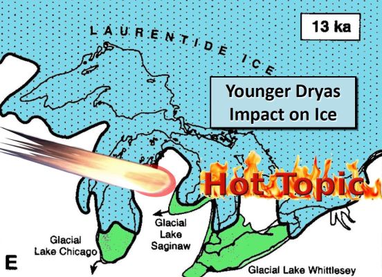
A 1973 publication by Huber shows the ice margin positions in thousands of radiocarbon years before the present. The highlighted position shows the ice advance over Saginaw Bay at 13.2 thousand years before the present. Pay attention to this line because we will refer to it later. Do you remember the reference to Dyke mentioned by Malcolm LeCompte in Graham Hancock's book? This is Dyke's 2004 paper, and it has several images showing ice coverage by radiocarbon age.
The image shows Saginaw Bay covered with ice at 13 thousand years before the present. So, according to Dyke, Saginaw Bay was covered with ice just before the onset of the Younger Dryas. The 2001 paper by Larson and Schaetzl is the second reference mentioned by Malcolm LeCompte in Graham Hancock’s book that supposedly confirms that there was no ice in Saginaw Bay at the onset of the Younger Dryas. One of the authors, Prof. Randall Schaetzl from Michigan State University, is the primary author of the commentary that objects to the impact hypothesis. The paper by Larson and Schaetzel provides images of the Laurentide Ice Sheet at various times during the Ice Age.
Larson and Schaetzl's Figure 6 illustrates the readvances of the Laurentide Ice Sheet at 15.5, 13, 11.8 and 10 thousand radiocarbon years before the present. A footnote on the first page says that throughout the paper "ka" refers to thousands of years, and that ages less than 65 ka are in radiocarbon years.
According to Larson and Schaetzl, the readvance of about 13.0 ka covered two thirds of the Michigan basin and most of the Huron basin and the eastern end of the Erie basin. Its maximum extent is marked by the Port Huron end moraine system which extends across southern Michigan and can be traced almost continuously eastward into the Ontario basin. This agrees with Dyke's 2004 paper and with Eschman and Mickelson's 1986 paper. The advance at 11.8 thousand BP, which is after the onset of the Younger Dryas, shows no ice in Saginaw Bay. By 10 thousand BP the ice had retreated to Lake Superior.
The paper by Larson and Schaetzl also has eight images in Figure 8 showing the locations and general extent of the major proglacial lakes associated with the retreat of the Laurentide ice sheet. I colorized these images for clarity. At 14 thousand years BP the Laurentide Ice Sheet covered a large portion of Michigan. At 13.6 thousand BP the ice retreated. At 13.2 thousand BP, Larson and Schaetzl illustrate Lake Huron without ice. This image differs substantially from the one by Huber that shows Lake Huron and Saginaw Bay covered with ice at 13.2 thousand years BP.
Just two hundred years later, at 13 thousand years before the present, Larson and Schaetzl illustrate Lake Huron and Saginaw Bay covered with ice. This is the time of the onset of the Younger Dryas and this ice coverage agrees with the image provided by Dyke in 2004 and with the image by Eschman and Mickelson in 1986 that I provided to Graham Hancock for his book. Thus, the 2001 paper by Larson and Schaetzl confirms that ice covered Saginaw Bay at the onset of the Younger Dryas. At 11.8 thousand BP the ice receded. And by 10 thousand BP the ice had receded further. By 5 thousand years BP the land was clear of ice and the Great Lakes took their present form.
A 1993 paper by Blewett, Winters and Rieck tested the Port Huron moraine and reported a radiocarbon age of 12,960 ± 350 yr BP from sediments immediately proximal to the northwestern part of the Inner Port Huron moraine in Michigan's Southern Peninsula. This paper and the three other sources that we already reviewed indicate that it is highly likely that the Laurentide Ice Sheet covered Saginaw Bay at the time of the onset of the Younger Dryas.
Where is the crater? Where is the crater? An extraterrestrial impact on an ice sheet would leave few traces on the land because the layer of ice attenuates the force of the impact preventing the formation of a typical crater. This has been demonstrated experimentally multiple times by Prof. Peter Schultz from Brown University. In addition, the heat of the impact melts the surrounding ice causing great flooding that scrubs the land and carries away evidence of the impact. Identifying the location of an impact on ice requires calculating the convergence point of the ejecta produced by the impact, but the convergence point is not likely to contain a typical crater due to the subsequent flooding.
Michael Davias integrated hundreds of LiDAR images of Carolina Bays and Nebraska Rainwater Basins with Google Earth. He used great circle trajectories adjusted for the Coriolis effect to calculate the convergence point of the bays at Saginaw Bay. If his calculations are correct, Saginaw Bay was the location of an extraterrestrial impact. The ice boulders ejected by the impact would have caused an extinction event from the Rocky Mountains to the East Coast of the United States and caused a global winter.
The date of the impact most likely coincides with the onset of the Younger Dryas cooling event and the megafaunal extinction in North America. Saginaw Bay may still contain some evidence of the impact, but most of the evidence probably just washed away when the glaciers melted. Scientists will eventually need to accept that the convergence point of the ejecta is probably the only way to identify the location of an extraterrestrial impact on ice.
