This presentation examines the timing of the flow of water from Lake Agassiz through an eastward outlet by the St. Lawrence river and proposes that an extraterrestrial impact by the Great Lakes helped to open this path.
Transcript:
The Younger Dryas was a cold period that started about 12,900 years ago and lasted for 1,200 years in the Northern Hemisphere. Some scientists have proposed that the overflow water from Lake Agassiz disrupted the circulation of the Atlantic Ocean and caused the Younger Dryas event. Lake Agassiz was a very large glacial lake in central North America. It formed from glacial meltwater at the end of the last glacial period and it had an area larger than all of the Great Lakes combined. The modern Lake Winnipeg is a remnant of Lake Agassiz.
A paper published in 2018 by David Leydet and nine co-authors, proposes that the onset of the Younger Dryas cold period was caused by a change in glacial Lake Agassiz overflow from its southern routing to the Gulf of Mexico to an easterly route toward the North Atlantic.
One of the co-authors is Prof. Andrew Breckenridge from the University of Wisconsin Superior. Prof. Breckenridge made some very informative comments about radiocarbon dates for a recent video.
Prof. Breckenridge is interested in understanding the nature of the drainage of Lake Agassiz by studying varved sediments, which are the annually deposited layers in the sediments of glacial lakes. By integrating the study of glacial varves with glacial landforms he can determine how ice sheets responded to climate change on annual time scales. A varve is simply an annual layer of sediment usually in a lake or marine environment. Seasonal or annual variations in deposition produce varves with contrasting layers. Core samples are obtained using special cylindrical drill bits.
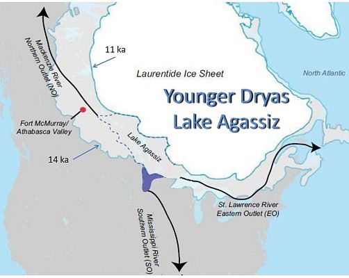
This image shows the heads of eastern outlet channels at the edge of Lake Agassiz as blue triangles, and the runoff paths are indicated by blue arrows. The red dot marked KM is the location where Beryllium-10 samples were taken near eastern glacial Lake Agassiz outlet channels. Moraines are shown as black dashed lines.
The main channel to the eastern Great Lakes and North Atlantic opened from about 13,000 to 12,700 years ago. This channel opening was concurrent with decreased runoff to the Gulf of Mexico and increased runoff through the lower Great Lakes to the Gulf of St. Lawrence and North Atlantic.
A satellite image shows the flow of Lake Agassiz via the Mississippi River toward the Gulf of Mexico. The pale green areas along the Mississippi valley indicate the enormous width of the channels carved by the flow of water.
This image shows the records of glacial Lake Agassiz basin routing. The yellow shading labeled "E" denotes a period starting from 13,000 to 12,700 thousand years ago when Lake Agassiz drained eastward through the Great Lakes and the St. Lawrence River toward the Atlantic Ocean. The blue shading labeled "N" marks the time around 12,200 years ago when Lake Agassiz started draining in a northwest direction via the Mackenzie River toward the Arctic Ocean. These changes in flow were due in part to isostatic rebound that raised the land after the huge weight of the ice sheets was removed. The authors conclude that the eastward flow of water could have caused the Younger Dryas climate change event.
The basic idea is that the water from Lake Agassiz overflowing via the St. Lawrence River would have disrupted the thermohaline circulation in the North Atlantic ocean and prevented the warm tropical water from reaching the northern hemisphere thereby causing the abrupt Younger Dryas climate event 12,900 years ago.
The Younger Dryas story can be summarized as follows: The main eastern channel from Lake Agassiz through the eastern Great Lakes and North Atlantic opened from about 13,000 to 12,700 years ago. The water flowing on the St. Lawrence River to the North Atlantic caused the abrupt climate change event. The isostatic rebound raised the land and caused Lake Agassiz to start draining in a northwest direction via the Mackenzie River toward the Arctic Ocean around 12,200 years ago. The draining of Lake Agassiz maintained a cold period for 1200 years.
But wait !!! The onset of the Younger Dryas is associated with more than just cold weather. A large platinum anomaly at the onset of the Younger Dryas was reported in 2013. The authors stated that the platinum could have come from an extraterrestrial source such as the impact of an iron meteorite with low iridium content, and that such a projectile would be unlikely to have resulted in an airburst.
Additional studies by Christopher Moore from the University of South Carolina found that the platinum anomaly is widely distributed throughout North America at the Younger Dryas Boundary. Some scientists have compared the platinum anomaly to the iridium-rich layer associated with the extinction of the dinosaurs.
Another geological feature associated with the onset of the Younger Dryas is a black mat. Fossils of megafauna and Clovis artifacts are found below the black mat layer, but not above. The organic-rich layer contains evidence of wet conditions such as diatomites and algal mats. The onset of the Younger Dryas is also associated with the extinction in North and South America of animals larger than approximately 44 kg or about 100 pounds.
The Glacier Ice Impact Hypothesis, published in 2017, proposed that an extraterrestrial impact on the Laurentide Ice Sheet ejected pieces of ice in ballistic trajectories and that the secondary impacts of the ice boulders created the Carolina Bays and the Nebraska Rainwater Basins.
The complete coverage of the Atlantic Coastal Plain by Carolina Bays indicates that the saturation bombardment by the ice boulders that made the bays would have caused an extinction event all the way from the Rocky Mountains to the East Coast of the United States. The energy of each impact was equivalent to 13 kilotons to more than 3 megatons of TNT.
The Carolina Bays and Nebraska Rainwater basins are perfect ellipses with raised rims whose major axes converge by the Great Lakes. Their radial alignment and elliptical geomorphology with raised rims indicate that these structures originated as conical cavities inclined at approximately 35 degrees.
Oblique impacts on a viscous surface create inclined conical cavities with raised rims that are elliptical when viewed from above. This corresponds to the geomorphology of the Carolina Bays. The impact origin of the Carolina Bays from secondary impacts of glacier ice is logical since ellipses are conic sections and inclined conical cavities are ellipses when viewed from above.
The paper by Laydet, et al. tells us that Lake Agassiz started draining eastward at the onset of the Younger Dryas, but it does not tell us why. Taking a broader perspective, we need to consider that an extraterrestrial impact on the Laurentide Ice Sheet at the onset of the Younger Dryas would have fragmented the ice by the Great Lakes and opened up the eastern outlet for the drainage of Lake Agassiz. The impact would also have ejected ice boulders that created the Carolina Bays, caused a megafaunal extinction, and dispersed platinum-rich material to create the platinum anomaly.
The revised Younger Dryas story goes something like this: An extraterrestrial impact on the Laurentide Ice Sheet by the Great Lakes opened an eastern outlet for Lake Agassiz and dispersed platinum-rich material widely. The secondary impacts of glacier ice ejected by the extraterrestrial impact killed fauna and created the Carolina Bays and Nebraska Rainwater Basins. Water ejected above the atmosphere by the extraterrestrial impact turned into a cloud of ice crystals that blocked the light of the sun and triggered a global winter. The water from Lake Agassiz flowing through the St. Lawrence River to the Atlantic Ocean, and later through the Mackenzie River to the Arctic Ocean maintained a cold period for 1200 years. All the pieces of the puzzle seem to fit.
