Structural geology measures the geometry of present-day geological formations to determine the history of deformation and understand the stress field that resulted in the observed characteristics.

Transcript:
Structural geology measures the geometry of present-day geological formations to determine the history of deformation and understand the stress field that resulted in the observed characteristics. Structural geology operates at scales ranging from microscopic lattice defects in crystals to mountain belts and tectonic plate boundaries. In this video I examine how the Carolina Bays fit within the framework of structural geology.
The book "Processes in Structural Geology and Tectonics" by Ben van der Pluijm and Stephen Marshak provides a contemporary synopsis of the broad conditions encountered in geologic settings. The information in this book makes it possible to suggest a regime for the formation of the Carolina Bays. Geology textbooks such as this usually cost hundreds of dollars, but in a departure from the expensive printed book model, this book is available only on-line, and you can request codes to access the book for free by emailing procsgt@gmail.com. The cost of books is not an excuse for not studying structural geology. You will find a link to the book in the video description below.
The authors of the book are Ben van der Pluijm, who is a geology professor at the University of Michigan-Ann Arbor, and Stephen Marshak, who is a geology professor at the University of Illinois, Urbana-Champaign. Professor Marshak has also authored an online geology course called Planet Earth and You, available from coursera.org The book is organized in three parts that correspond to the deformation regimes that create geological features.
The frictional regime explains the behavior of hard structures that can break. The plastic regime explains the geological structures that are created when the material can be deformed without breaking. The final section of the book explains plate tectonics, which is the interaction of rigid lithospheric plates on the surface of the Earth that move slowly over the underlying mantle.
The introduction of the book describes many types of geological structures, including surface markings, like the ripples formed by flowing water and impact structures, such as Meteor Crater in Arizona.
The introduction of the book also has a figure that summarizes deformation regimes and their characteristics. Processes governed by friction occur in the upper part of the Earth's crust, where temperatures and pressures are relatively low, whereas plastic processes describe deformation in the middle and lower part of the crust and the mantle under conditions of greater pressure and temperature. We will examine this figure in greater detail.
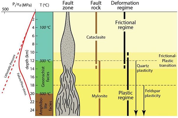
The right portion of the image illustrates the deformation regime relative to the temperature and depth within the Earth. The frictional regime operates between the surface of the Earth to a depth of about 12 kilometers where the temperature is approximately 300 degrees Celsius.
The left column of this figure has a dashed straight red line representing the lithostatic pressure in megapascals that corresponds to the weight of the earth as the depth increases.
The curved red line marked as Failure/Flow stress represents the rock strength. This is the pressure that is required to cause deformation. Notice that the maximum rock strength is encountered about 12 kilometers beneath the surface, which is where the frictional regime transitions to the plastic regime.
Cataclasite is given as an example of the rocks formed under the frictional regime. This is an image of cataclasite. Cataclasites are composed of large fragments of the pre-existing rock in a matrix consisting of crushed microfragments that cohesively hold the rock together. The large fragments are highlighted here.
Notice that this is image has been greatly magnified. The scale bar shows 200 micrometers, or two hundred millionths of a meter. The whole image corresponds to a portion of rock measuring about 2 millimeters, which is about half the size of grain of rice.
The plastic regime at the bottom of the chart starts 12 kilometers below the surface of the earth, and goes down to at least 24 kilometers below the surface. Quartz plasticity starts at about 12 kilometers below the surface of the Earth where the temperature is 300 degrees Celsius and continues to the bottom of the chart at 24 kilometers below the surface. Feldspar plasticity starts at about 18 kilometers below the surface of the Earth where the temperature is close to 500 degrees Celsius and continues to the bottom of the chart as indicated by the arrows. At the pressure and temperature conditions typical of the middle crust, quartz is mechanically weaker than feldspar due to the crystal plasticity.
Here are samples of quartz and feldspar. Quartz is a hard, crystalline mineral composed of silica (silicon dioxide). Quartz is the second most abundant mineral in Earth's continental crust, behind feldspar. The sand that you find in a beach consists mainly of silicon dioxide in the form of quartz.
Feldspars are rocks formed from aluminum silicate minerals that contain sodium, calcium, and potassium. Feldspars make up about 60% of the Earth's crust, and 41% of the Earth's continental crust by weight.
Mylonite is given as an example of the rocks formed under the plastic regime. Mylonite is a fine-grained, rock produced by dynamic recrystallization of the constituent minerals resulting in a reduction of the grain size of the rock. Mylonites can have many different mineralogical compositions; it is a classification based on the textural appearance of the rock. This image uses a 1 Euro coin for scale. Looking at the mineral striations, it becomes clear what the fault zone column represents.
In the frictional regime, the rocks in the fault zone are typically granular as the minerals break by contact with each other, but in the plastic regime, the rocks in the fault zone are typically striated as the minerals melt and recrystallize when they come together under high temperature and high lithostatic pressure.
Facies refers to the character of a rock expressed by its formation and composition. Greenschists are metamorphic rocks that form typically from 300 to 450 degrees Celsius. Greenschists commonly have an abundance of green minerals that are oriented in such a way that the rock is easily split into thin flakes or plates. Amphibolite is a grouping of silicate rocks containing little or no quartz and the crystals form tetrahedral structures. The frictional regime describes faults and faulting.
This figure identifies several types of faults. In a strike slip fault, two geological areas slide horizontally along each other. A normal fault occurs when a portion of the terrain slips downward, relative to the its previous position. A reverse fault occurs when a portion of the terrain slips upward, relative to the its previous position. An oblique reverse fault occurs when a portion of the terrain slips upward and sideways, relative to the its previous position. The book has pictures of normal faults, reverse faults and a strike-slip fault represented by the San Andreas fault in California. This is one of my favorite rocks. It is a decorative rock for landscaping that I found at a shopping center. The stone has a normal fault.
It seems that additional layers of sediment were deposited after the fault was created. The rock eventually tumbled into a creek and became rounded as it rolled in a stream bed before finally ending up in the palm of my hand for a geology discussion. The book is very large, so I am skipping around to point out some interesting things. I highlighted the columnar joint pattern because there is a World Heritage Site in Northern Ireland that has a beautiful example.
This is an image from Wikipedia of the Giant's Causeway. It is an area of about 40,000 interlocking basalt columns that formed as the result of an ancient volcanic eruption. The tops of the columns form stepping stones that lead from the cliff foot and disappear under the sea. Most of the columns are hexagonal.
This figure from section 5 of the book illustrates faults on the left and shear zones on the right. At the low temperatures near the surface, geologic forces cause the rocks to break creating faults. At the higher temperatures encountered below 10 kilometers from the Earth's surface, the rocks undergo a plastic flow that produces shear zones but no breakage when a force is applied.
Section 8 of the book describes folds and their basic terminology. The section on plate tectonics is extensive and describes the characteristics of the Earth's layers, including the crust, the mantle and the core.
This generalized diagram illustrates the forces acting on tectonic plates. My review of this book has omitted many details. Professors Ben van der Pluijm and Stephen Marshak have done a remarkable job in assembling this textbook of structural geology. They should also be praised for making the textbook freely available to the geology community and the public at large.
The Carolina Bays are the most prevalent geological structures in the Atlantic Coastal Plain, and I want to be able to determine where they fit within the framework of structural geology. Well-preserved Carolina Bays have a precise mathematical elliptical geometry. They are conic sections. This implies that they formed as inclined conical cavities. Experiments confirm that oblique impacts of ice projectiles on a viscous target produce inclined conical cavities that are elliptical when viewed from above.
A model for the geomorphology of the Carolina Bays published in 2017 proposed that an extraterrestrial impact on the Laurentide Ice Sheet ejected glacier ice boulders in suborbital trajectories that created inclined conical cavities and then transformed into shallow elliptical bays by viscous relaxation.
It is evident that the Structural Geology model needs to have a cold plastic regime in addition to a hot plastic regime. The cold plastic regime requires the presence of water to produce the viscous terrain suitable for plastic deformations.
Shaping a clay pot or molding bricks are examples of plastic deformations. Soil liquefaction by earthquakes or impacts on a viscous surface also produce plastic deformations. All of these deformations require the presence of water in clay or in unconsolidated ground. These deformations, whether man-made or natural, are the result of a cold plastic regime.
I propose adding a cold plastic regime to the current geological model. It would operate on the surface of the Earth where water is present. This will allow the integration of the Carolina Bays within the framework of structural geology.
