Discussion of the global temperature changes, volcanic events, and extraterrestrial impacts that contributed to the deglaciation of the Laurentide Ice Sheet and the Cordilleran Ice Sheet that covered Canada during the Ice Age.
Transcript:
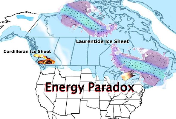
The Energy Paradox. At the end of the Last Glacial Maximum, about 20,000 years ago, much of Earth in the northern hemisphere was covered by ice. The Laurentide Ice Sheet covered much of Canada and the northern United States with a mass of ice that was nearly 4 km thick in some places. The rapid melting of the ice sheets has puzzled scientists because the periods of melting and splintering into the sea occurred at the coldest times of the last Ice Age. Recent research has identified a new mechanism that may explain the rapid disappearance of the ice sheets. The rate of melting of the ice sheets can be deduced from the rise of sea level, which has varied over the last 20,000 years. The fastest rise in sea level occurred during Meltwater pulse 1A and Meltwater pulse 1B.
Meltwater pulse 1A occurred between 15,000 and 13,000 years ago at the time of the cataclysmic Missoula floods that covered eastern Washington along the Columbia River Gorge. This time encompasses the Bølling-Allerød interstadial, which was a period of warm climate during the final stages of the last glacial period. Meltwater pulse 1A raised sea level by about 25 meters or 82 feet. Meltwater Pulse 1B occurred between 11,500 and 11,200 years ago after the end of the Younger Dryas cooling event. It increased sea level by 28 meters or 92 feet, but it has been difficult to attribute a cause for the rapid sea level rise. This chart shows the temperature record for the past 20,000 years obtained from the Greenland Ice Sheet Project Two and the Cariaco Basin in Venezuela.
The Bølling-Allerød interstadial was a period of warm climate during the final stages of the last glacial period from about 14,700 to 12,700 years before the present. The Younger Dryas was a sudden cooling event from 12,900 to 11,700 years before the present. The Younger Dryas is remarkable because of its rapid onset and its equally fast termination. In addition to the higher temperatures of the Bølling-Allerød interstadial and the end of the Younger Dryas, volcanic activity may have contributed to the melting of the Cordilleran Ice Sheet. Glacial surges that dumped ice from the land unto the sea could have reduced the ice mass over land and increased the sea level. Some scientists have suggested that a comet impact over North America 12,900 years ago could have destabilized the ice sheets and increased the rate of melting. We will now examine these three ideas.
The Missoula Floods were cataclysmic floods that swept across eastern Washington and down the Columbia River Gorge at the end of the last ice age. The floods occurred between 15,000 and 13,000 years ago. Lake Missoula measured about 7,770 square kilometers and contained about 2,100 cubic kilometers of water, which was about half the volume of Lake Michigan. The flood waters contained large icebergs that scoured the land creating scablands with giant ripples. The melting icebergs left a landscape covered with erratic boulders carried within the glacier ice. The melting of the Cordilleran Ice Sheet that covered western Canada has been attributed to the warm weather during the Bølling-Allerød interstadial.
However, the Cordilleran Ice Sheet was located on top of a large volcanic province in British Columbia. It is possible that a volcanic eruption under the ice sheet could have provided the meltwater for the glacial lakes Columbia and Missoula.
Volcanoes and earthquakes occur where the Pacific plate is subducting under the North American Plate along British Columbia and Washington state. Volcanoes can explode, produce lava, and then they can cool and become dormant for hundreds of years. If a volcanic eruption happens under an ice sheet, it can melt the ice and cause massive flooding. A jökulhlaup is a glacial outburst flood triggered by geothermal heating or by a volcanic subglacial eruption. The term originally referred to the subglacial outburst floods in Iceland, but it has been adopted in geology to describe any large and abrupt release of water from subglacial lakes.
Several ideas have been considered for the deglaciation of the Laurentide Ice Sheet. In 2007, Anders Carlson proposed that the loss of high albedo on the surface of the ice sheet may have allowed the solar radiation to melt more ice. Albedo refers to the whiteness or reflectivity of a surface.
A paper by David Ullman suggests that differences in the Earth's orbit 8,000 years ago allowed more solar energy to reach the northern hemisphere and increased the melting of the Laurentide Ice Sheet. A 2008 paper by Carlson, et al. proposes that increased ablation due to enhanced summer insolation was the main cause of the Laurentide Ice Sheet retreat. In other words, the summer sunshine melted the ice. This paper published in 2019 by Barth and three co-authors attribute the thinning of the Laurentide ice sheet to the Bolling-Allerod warming.
A paper published in November of 2019 by Whyjay Zheng, et al. describes a deglaciation process that had not been observed before. The authors describe a glacier surge that became an ice stream and caused irreversible ice loss of 11% of the entire basin at the Vavilov Ice Cap in Russia in the span of six years. For context, the Vavilov Ice Cap is in the Arctic Circle about 1200 kilometers from the North Pole. The principal author of the paper, Whyjay Zheng says that "If you look at the satellite images, it seems like the entire west wing of the ice cap is just dumping into the sea. No one has ever seen this before."
The main evidence that the glacier surge turned into an ice stream is the emergence of "shear margins" around the stream. A surge is just a rapid dumping of ice into the water, but just like liquid water forms streams on land, ice streams develop clearly-demarcated paths through the landscape. The edges of the new ice stream, as seen from a satellite, are darker and less reflective, according to the researchers. That is indicative of a long-lasting region of fast-moving ice meeting the slower region around it.
This graph correlates the temperature with the speed of the glacier stream from 2015 to 2019. Each point in the bottom chart is an average speed during the period bounded by its horizontal bar, with the 2 sigma uncertainty indicated by the vertical bar. Notice that in 2016 the glacier ice reached speeds of 20 to 25 meters per day. The rapid movement of glaciers over land strips the topsoil and leaves a rocky terrain with striations marking the passage of the glacier. When the glaciers melt, they drop stones contained within the ice and leave erratic boulders that have been carried great distances. This photograph shows the barren terrain in Peggy's Cove, Nova Scotia.
This experiment demonstrates that sea level can rise when ice moves from the land to the sea. The cup represents the land, and as long as the glacier ice is on top of the land, the sea remains at a lower level, but as soon as the glaciers become icebergs in the ocean, the sea level rises even before the ice melts.
A paper published by Jeremy Bassis, et al. in 2017 examined the sediments produced by discharges of icebergs from the Laurentide Ice Sheet through the Hudson Bay strait. The authors found that massive discharge events occurred during the cold portion of climate oscillations, which is counterintuitive. The authors created a model that takes into account how the Earth’s surface reacts to the weight of the ice on top of it. The model shows how small spikes in the temperature of the ocean, rather than the air, likely drove the rapid disintegration cycles of the expansive ice sheet that once covered much of North America.
Heavy ice depresses the planet’s surface, at times pushing it below sea level. That’s when the ice sheets are most vulnerable to warmer seas. But as a glacier retreats, the solid Earth rebounds out of the water again, stabilizing the system. It is also necessary to consider the effect that a comet impact would have had in the deglaciation of the Laurentide Ice Sheet.
In 2007, Firestone and 25 co-authors proposed that one or more large, low-density extraterrestrial objects exploded over northern North America, partially destabilizing the Laurentide Ice Sheet and triggering the Younger Dryas cooling. The authors also suggested that the ET impact caused extensive biomass burning and the extinction of the North American megafauna. This hypothesis was met with great skepticism, but subsequent studies have found that the Younger Dryas boundary layer is enriched in platinum, possibly from an extraterrestrial origin. The location of a potential impact may be indicated by the orientations of the Carolina Bays and the Nebraska Rainwater Basins.
The Carolina Bays are shallow elliptical depressions with raised rims on unconsolidated ground whose major axis is oriented toward the Great Lakes. The size of the bays varies from about one hundred meters to several kilometers in size. The bays are found on sandy soil close to the water table along the East Coast of the United States. The Nebraska Rainwater Basins have a similar geometry as the Carolina Bays and they are also oriented toward the Great Lakes.
In 2010, Davias and Gilbride calculated the convergence of the major axes of the Carolina Bays and the Nebraska Rainwater Basins at Saginaw Bay, Michigan. An extraterrestrial impact at this location during the ice age would have fractured the Laurentide Ice Sheet and sent ice boulders in ballistic trajectories to produce inclined conical cavities that now appear as elliptical structures.
The Laurentide Ice Sheet had three major drainage areas: 1) the St. Lawrence river toward the Atlantic Ocean, 2) the Mackenzie River toward the Arctic Ocean, and 3) the Mississippi River toward the Gulf of Mexico. The Mississippi river carried the glacial meltwater of Lake Agassiz, but glacier surges could have transported ice northward toward the Arctic Ocean, and eastward toward the Atlantic Ocean. As the oceans filled with icebergs, the sea level increased causing additional warm water to come in contact with the glaciers on the land, thus triggering a runaway feedback cycle of frequent glacial surges, ice streams, and Heinrich events that caused the rapid deglaciation of the Laurentide Ice Sheet.
A big question is whether what happened to the Vavilov Ice Cap could happen to the glaciers in Greenland. We really don't know, but if a glacier surge happened in Greenland, all the seaports of planet Earth would be in danger of flooding.
