Some scientists attribute the formation of the Carolina Bays to wind and water mechanisms, but there is no evidence that wind can create elliptical structures like the bays.
Transcript:
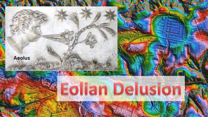
This presentation examines the hypothesis that the Carolina Bays were created by the action of the wind, but it turns out that this is a widely held misconception or an eolian delusion. In Greek mythology, Aeolus was the keeper of the winds, so the word eolian refers to something that is carried, deposited, produced, or modified by the wind.
The Carolina Bays are shallow elliptical depressions with raised rims that have their major axis oriented toward the Great Lakes. They are found on unconsolidated soil along the Atlantic Coastal Plain from New York to Florida, but they are most prominent in North and South Carolina. Many well-preserved Carolina Bays are found near Myrtle Beach, South Carolina, where their remarkable shape was observed in the first air surveys in the 1930s after the invention of the airplane.
In 1942, Professor Douglas Johnson from Columbia University wrote a book entitled The Origin of the Carolina Bays, where he proposed that the bays originated from lakes formed by artesian springs whose sandy rims were formed by the action of the wind. Throughout his book, Professor Douglas referred to the bays as having an oval rather than an elliptical shape, even though it was relatively easy to verify the elliptical geometry of the bays in the images that he published in his book. Professor Johnson considered the Carolina Bays to be blowouts created by wind erosion that were bordered by dunes and he dedicated a chapter of his book to describe the eolian phase of his hypothesis.
Professor Johnson opposed the idea that the Carolina Bays were created by impacts, as had been proposed in 1933 by Professors Melton and Schriever from the University of Oklahoma. One of the most important features of the Carolina Bays mentioned by Melton and Schriever was the smoothly elliptical shape of the bays, and their paper included a graph of the ellipticity versus length of the bays, which showed that ellipticity increased in direct proportion to the major axis of the bays. The geometry of the Carolina Bays was well documented at the time that Professor Johnson wrote his book, but he simply dismissed this fact as unimportant.
Professor Douglas Johnson was very influential. His idea that the Carolina Bays were formed as shallow lakes modified by the wind was referenced in 2010 by Mark Brooks, Barbara Taylor and Andrew Ivester. These authors wrote that the Carolina bays formed during the Pleistocene as shallow lakes on undissected land surfaces of the Atlantic Coastal Plain from southeast New Jersey to northeast Florida (Johnson 1942). The distinctive shape and northwest-southeast orientation of bays developed through stronger-than-present southwesterly winds blowing over water ponded in shallow depressions.
The depressions were expanded and oriented by wave erosion, resulting in bay elongation perpendicular to wind direction and the formation of peripheral, downwind sand rims and shorelines on the eastern and southeastern margins. This publication mentions several papers that estimate the creation of the bays to be between 7 thousand to 200 thousand years before the present.
Brooks, Taylor and Ivester referenced Kaczorowski 1977 as a source for the mechanism of bay elongation perpendicular to wind direction, but they did not mention the elliptical geometry of the Carolina Bays or the idea that the bays could have been created by impacts.
Brooks and Ivester were co-authors of a paper published in 2016 about the evolution of a Carolina Bay in which they described Kaczorowski's work as follows: Seminal work by Kaczorowski's (1977) on bay formation and evolution demonstrated that Carolina bays evolve through the interactions of strong, late Pleistocene directional winds on shallow, ponded water, producing oriented lakes; similar oriented lakes are a relatively common phenomenon globally. Through the use of wind table modeling, Kaczorowski demonstrated that strong prevailing winds (from the southwest in the Carolinas) were responsible for creating circulation cells that shaped natural depressions into ellipses and oriented bays perpendicular to prevailing wind.
The citation to Kaczorowski 1977 refers to a technical report written by Raymond Kaczorowski titled The Carolina Bays: a comparison with modern oriented lakes. The report was prepared for the Coastal Research Division of the Department of Geology at the University of South Carolina in Columbia. It was never subjected to a peer-review and it was never published in a professional geology journal.
Kaczorowski wanted to show that the Carolina Bays had been created by uniformitarian processes, such as wind, rather than by impacts. He conducted a sand table experiment where he carved a circular pool and set a fan to blow over the pool. Page 93 of the technical report has an image of his experiment with a caption that says: "A diagrammatic representation of model lake changes from circular to elliptical perpendicular to the influence of opposing winds alternated every fifteen minutes for a total of four hours. Sediment removed from the maximum transport zones along with sediment derived from near shore areas produced a net accretion in the areas where wave approach angle was low. Initial lake diameter was 65 cm."
Even though Kaczorowski described his experiment as changing the pool from circular to elliptical, the experiment only produced a structure like a bloated American football with pointy ends, which did not have the smooth geometrical characteristics of an ellipse. In addition, by alternating the direction of the wind in opposite directions every 15 minutes, Kaczorowski created conditions that are not found in nature, which would invalidate his conclusions.
In 2001 William Zanner and Mark Kuzila from the University of Nebraska presented a paper with the title: Nebraska's Carolina Bays in which they described a multitude of oval shaped features called rainwater basins that share southwest to northeast orientations and that are perpendicular to regional prevailing wind directions. Zanner and Kuzila suggested that the Nebraska Rainwater Basins originally formed as blowouts or low spots in abandoned Platte River fluvial sands and gravels. Notice that the basins are described as oval, rather than elliptical, and that the proposed mechanism of formation is by blowouts of wind action.
LiDAR images using a laser ranging technology make it possible to demonstrate that the Nebraska Rainwater Basins have the same elliptical geomorphology as the Carolina Bays, and that their major axes converge by the Great Lakes. This information was available in 2001, but the publications by Brooks and Ivester in 2010 and 2016 do not mention it.
It is not surprising that even in 2020 the Carolina Bays are described by Christopher Swezey of the US Geological Survey as adjacent to eolian dunes that are primarily parabolic. The Nebraska Rainwater Basins, which might provide some context to the Carolina Bays, are not mentioned at all since Swezy's article only described the Atlantic Coastal Plain.
Wind is a powerful force and eolian processes can transform a landscape. Wind can carry dust for great distances and deposit it far away from its origin to create sand dunes that shift over time. The dust carried by the wind also acts as an abrasive that wears away rocks. But is it possible for the wind to carve precisely elliptical features like the Carolina Bays?
If the wind could produce "blowouts" in the ground we would surely see them in Oklahoma which has the greatest number of tornadoes per year. Instead, we see that the powerful winds of tornadoes topple down trees, destroy houses, and even lift cars into the air, but they do not dig holes in the ground. These strong swirling winds do not create Carolina Bays.
The Dust Bowl was a period of severe dust storms that greatly damaged the ecology and agriculture of the American prairies during the 1930s. Severe drought and a failure to apply dryland farming methods caused the wind to create huge dust storms. The wind blew away much of the topsoil, but no Carolina Bays were created. The creation of an elliptical structure on the land requires a mechanism of great precision. The idea that eolian blowouts can create elliptical Carolina Bays is just a delusion.
Eolian Delusion. Once upon a midnight dreary, while I pondered, weak and weary, Over many a quaint and curious volume of geologic lore, While I nodded, nearly napping, suddenly there came a pounding, As of glacier ice chunks crashing, pummeling the Eastern shore. Let my mind expand a moment and this mystery explore, 'Tis the wind, I said, 'tis the wind and nothing more!
Some belief systems are ingrained in our society. Life after death is the belief that some part of us lives forever in the afterlife. The Egyptians went to great lengths to mummify and prepare goods for the dead so that they would have a good journey in the afterlife. Even today, many people believe in an afterlife. Please, all of you who believe in life after death raise your hand. Don't be shy. Raise your hand if you believe in life after death. Unfortunately, you are all wrong. There is no evidence for life after death. The only way that we live after death is in the minds of those who remember us and our actions. This is why the Egyptian pharaohs chiseled out the names of their enemies in their memorials so that they would not be remembered. This really works. Once your name and your deeds are forgotten, it is as if you had never existed.
The belief that the Carolina Bays were created by wind and water mechanisms is very prevalent in spite of the complete lack of evidence. It is our modern mythology. It is not science. When we allow ourselves to accept beliefs without evidence, our mind cannot distinguish fantasy from reality. Sure, wind and water can modify the Carolina Bays, but wind and water mechanisms cannot explain the origin of the geometrically elliptical features in the East coast and in Nebraska, both of which are radially oriented toward the Great Lakes.
As Melton and Schriever pointed out in 1933, one feature that is unique to the Carolina Bays is their elliptical geomorphology. Well preserved Carolina Bays can be precisely fitted with ellipses that have the same width-to-length ratios as the bays.
If only a few bays were elliptical, we could attribute that to chance, but when we can find a multitude of bays with elliptical geometry, this tells us something about their mechanism of formation. Three features about the Carolina Bays stand out: the elliptical geometry, the raised rims, and the orientation toward a convergence point by the Great Lakes.
Ellipses are conic sections, and this implies that the Carolina Bays originated as inclined conical cavities that were later remodeled into shallow elliptical bays by viscous relaxation. The raised rims are characteristic of impacts.
Experiments demonstrate that oblique impacts on a viscous surface create inclined conical cavities or penetration funnels that look elliptical when viewed from above. The conical cavity formed by an oblique impact is surrounded by a raised rim that is formed from overturned flaps typical of impact craters. The penetration of the projectile into the medium produces horizontal compressive forces and ejects debris ballistically that create the stratigraphically uplifted rims.
Melton and Schriever in 1933 reported that the Carolina Bays have mutual interference of outline, which means that the bays may overlap while maintaining their elliptical geometry. This characteristic was not addressed by Kaczorowski in his 1977 technical report, and it is not clear how wind processes could create a landscape with multiple bays having various kinds of overlaps while maintaining the elliptical geometry of the bays. It is perplexing that scientists can believe that wind and water produced these overlapping structures without questioning the exact mechanism by which they were produced.
If the Carolina Bays were formed 7 thousand to 200 thousand years before the present, how did they keep their elliptical geometry for thousands of years? If wind and water made the overlapping bays, why didn't the creation of the top bay destroy or alter the shape of the bottom bay? If wind and water made the bays, why aren't any new Carolina Bays being made at the present time? These are the questions that scientists should be asking.
Adjacent oblique impacts can be shown to produce penetration funnels that overlap in the same sequence in which they are made. Viscous relaxation reduces the depth of the cavities to create overlapping features with raised rims. Advocates of the wind and water mechanisms for the formation of the Carolina Bays should attempt some experiments to model overlapping bays.
We have seen that even tornadoes do not create blowouts like the Carolina Bays. The Carolina Bays in the gravels near Midlothian, Virginia could only have been created by impacts because the gravel chunks are too big to be blown by the wind. A paper by Bruce Goodwin and Gerald Johnson published in 1970 provides some information about these Carolina Bays.
Goodwin and Johnson illustrate the presence of several Carolina Bays on the Midlothian gravels. A LiDAR image of the same terrain shows that the area is completely urbanized and many houses have been built within the boundaries of the bays. Goodwin and Johnson describe the terrain as follows.
Midlothian is located approximately 13 miles west of Richmond and four miles south of the James River. In this area, coarse upland gravels overlie igneous end metamorphic rocks of Precambrian and Paleozoic age and sedimentary rocks of Triassic age. The gravels, which represent only the remnants of formerly more extensive gravel deposits in this area, cap more than 20 square miles of upland. In this guidebook they will be referred to as the Midlothian gravels. Circular to elliptical depressions occur on relatively undissected tracts of upland gravels at altitudes of 350 to 370 feet. The depressions which are less than 15 feet deep are commonly bounded by a raised rim. They vary in maximum diameter from a few hundred feet to more than three quarters of a mile. Their centers are often swampy due to the lack of external drainage. These depressions are tentatively designated as Carolina Bays.
The most striking feature of the Midlothian gravels is the thick gravel member. The gravel member, which ranges in thickness from zero to nearly 40 feet, is composed of abundant pebbles and cobbles in a sandy matrix containing variable amounts of clay. Although cobbles up to nine inches in maximum diameter were observed, the average cobble measures two to three inches in diameter. The cobbles are well-rounded and sphericity varies from low to high. Discoid cobbles tend to be oriented parallel to the bedding. No distinct graded bedding or imbrication of cobbles or pebbles was observed. Bedding within the gravel member is indistinct or lacking.
Cobbles are pieces of rock larger than a pebble and smaller than a boulder. The average cobble in the Midlothian gravel field measures two to three inches in diameter or 5 to 7.6 centimeters. Those cobbles are about the size of the palm of your hand. They are not easily blown around like tiny grains of sand.
The area around Richmond, Virginia east of the Midlothian gravels is significantly eroded, but some areas retain evidence of Carolina Bays. Looking at a LiDAR image of the terrain without the highways we can see several places with Carolina Bays. The largest bay, which measures 8,100 meters, is located just east of the city of Richmond. Water erosion has destroyed much of the bay, but the elliptical rim of the bay can still be discerned. Even though some portions of the ellipse are missing, it is mathematically possible to determine the shape of a partially obscured bay from 5 points along its curve.
The occurrence of Carolina Bays on the Midlothian gravels with cobbles that measure two to three inches in diameter offer substantial evidence that the wind could not have been responsible for the formation of these bays. It is time to discard the eolian delusion and replace it with facts.
