Description of the Carolina Bays in the gravels near Midlothian, VA and the possible role of acoustic fluidization in their formation.
Transcript:
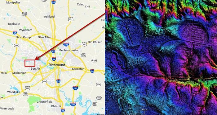
It is common to find Carolina Bays on sandy soil close to the Atlantic seacoast. This video describes Carolina Bays at more than 100 meters above sea level that formed on gravel. In 1970, Bruce Goodwin and Gerald Johnson published a document which described the geology of the upland gravels that overlie the bedrock in the vicinity of Midlothian, Virginia, located approximately 13 miles west of Richmond and four miles south of the James River. The City of Richmond straddles the Fall Line that marks the boundary of an upland region of relatively hard crystalline rock and a coastal plain of softer sedimentary rock. The bedrock consists of igneous and metamorphic rocks of Paleozoic age and sedimentary rocks of Triassic age. This means that the bedrock was emplaced at least 250 million years ago.
The circular to elliptical Carolina Bays occur at altitudes of 350 to 370 feet above sea level. That is 107 to 113 meters above sea level. The bays are on tracts of upland gravels that have not been eroded by water. The bay depressions are less than 15 feet or 4.5 m deep and are commonly bounded by a raised rim. They vary in maximum diameter from about 500 feet (or 150 m) to more than three quarters of a mile (which is 1.2 km). Their centers are often swampy due to the lack of external drainage. The gravel deposits, shown here in white, cap more than 20 square miles of upland. The edge of the gravel cover is usually marked by a pronounced steepening of hill slopes where the gravels have resisted erosion more effectively than the underlying terrain. The thickness of the gravel field varies from almost nothing to nearly 40 feet or 12 meters. The gravel is composed of abundant pebbles and cobbles in a sandy matrix containing variable amounts of clay. The cobbles are well-rounded and average 2 to 3 inches in diameter, which is about 5 to 8 cm.
Goodwin and Johnson were unable to assign a specific age to the Midlothian gravels because of the uncertainties of Tertiary and Mesozoic tectonics, the lack of fossil evidence, and the isolated nature of the upland gravels. However, the deep weathering profile of the gravels and their isolated nature suggest that the upland gravels are more than 2 million years old and may have formed before the Pleistocene. The lower image shows the cross section of the terrain corresponding to the red line in the upper image. A shallow Carolina Bay is marked in the cross section.
The elliptical geometry of the Carolina Bays is best explained as mathematical conic sections. The Glacier Ice Impact Hypothesis proposes that a meteorite impact on the Laurentide Ice Sheet ejected pieces of ice in ballistic trajectories. The impacts of these ice boulders with energies of 13 kilotons to 3 megatons liquefied unconsolidated ground and allowed the ice boulders to create inclined conical cavities that became shallow elliptical bays by viscous relaxation. The seismic vibrations corresponding to these impacts were equivalent to earthquakes of magnitude 6.0 to 7.5, so they had the energy necessary to liquefy soil.
This LiDAR image shows the Carolina Bays on the upland gravels south of the James River. The color gradient indicates the elevation. The upland gravels around Midlothian are isolated and have been truncated by erosion on all sides. They are completely surrounded by exposures of much older rocks that lack a gravel cover. The gravels range in thickness from a feather edge to more than 40 feet. The average thickness is approximately 20 feet. Overlaying the maps made in 1970 with the modern LiDAR image we can see that the features match well, but LiDAR shows many details that were not represented in the line drawing.
Professor Jay Melosh introduced the concept of acoustic fluidization in 1979 to explain the low strength and viscosity exhibited by the collapse of impact craters on the Moon. Strong vibrations from the shock of an impact could briefly fluidize the rocky debris in a planet lacking water or air. This would cause the dry, broken rock debris to flow like a liquid. Acoustic fluidization only supposes that a mass of dry rock debris is fluidized by the fluctuating pressures induced by strong vibrations or acoustic waves traversing the mass. Individual clasts or large rocks, normally pushed tightly against each other by the pressure of overlying rock debris, suddenly become free to slip during a transient low pressure fluctuation. Professor Melosh's fluidization mechanism may be applicable to the upland Midlothian gravels. The impacts of glacier ice would have produced seismic vibrations capable of acoustically fluidizing the Midlothian gravel bed to allow the formation of Carolina Bays.
During the summer of 2016, Michael Davias conducted a coring operation on the Midlothian platform. The goal of the operation was to reach the bedrock beneath the gravel, but it was not reached as expected at a depth of 48 ft or 16 meters. This image shows the coring operation and a photograph of part of the core. Michael found that the gravel in the cores consists of pebbles up to 1 inch in diameter in a matrix of coarse quartz sand. The operation produced 12 core tubes that were photographed and sent for storage at the Virginia Institute of Marine Science core repository.
In March of 2011, Michael visited the Midlothian bays and found that while the bays may rest on gravel, they are composed mostly of pure sand. He took some samples where a new house was being built, and found a large uprooted tree in the rear lot where soil from two feet down was exposed for sampling.
By proclaiming that the bays were created by wind and water mechanisms, professional geologists erroneously placed Carolina Bays in the same category as ephemeral structures such as sand dunes. Michael Davias used LiDAR data to show that the Carolina Bays and the Nebraska Rainwater Basins with the same geometrical morphology are persistent structures that converge at Saginaw Bay by the Great Lakes. This was a fundamental discovery that strongly indicates that the Carolina Bays formed as a result of an extraterrestrial impact. At his own expense, Michael Davias established Cintos.org to provide free access to LiDAR images that integrate seamlessly with Google Earth. All the LiDAR images in this video came from Cintos.org. Michael continues to improve his web site and to do geological field work on the Carolina Bays. He would like to date some of his core samples using isotopic techniques, but he says: "This will cost big bucks, and I am awaiting the lottery winnings, or getting someone motivated to do it for free." If you are interested, he has a donation button and contact information in his web site.
