This presentation discusses a publication about Herndon Bay and the paradigm shift that will occur with the recognition that the Carolina Bays were created by secondary impacts of glacier ice.
Transcript:
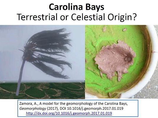
We know that the Carolina Bays are not of extraterrestrial origin because they do not have the shock metamorphism, meteorite fragments or other evidence of extraterrestrial impacts. Two hypotheses have emerged about their origin. The terrestrial hypothesis posits that the Carolina Bays formed gradually over thousands of years by the action of wind and water on the landscape. The celestial hypothesis states that all the bays were created within a few minutes after an extraterrestrial impact. In 2009, Firestone suggested that the Carolina Bays could have been created from the winds of the shockwave of the extraterrestrial impact. The Glacier Ice impact Hypothesis, published in 2017, proposes that the Carolina Bays formed from secondary impacts of glacier ice ejected in ballistic trajectories by an extraterrestrial impact on the Laurentide Ice Sheet.
The terrestrial and celestial hypotheses are mutually exclusive. The terrestrial hypothesis offers evidence of a wide variety of dates found on the terrain with the Carolina Bays to argue that all the bays could not have formed in a single event. The Glacier Ice Impact Hypothesis points out that the Carolina Bays have a mathematically elliptical morphology and that they originated as inclined conical cavities that transformed into elliptical bays by viscous relaxation. The terrestrial hypothesis has had the greatest number of supporters for over 80 years. However, mounting evidence for the celestial hypothesis indicates that a paradigm shift is coming.
A paradigm shift is a significant change in mainstream ideas, and it can be long and painful. Here is an example of a paradigm shift that took place 400 years ago. In the 2nd century AD, Claudius Ptolemaeus standardized a geocentric system where all the planets and the Sun revolved around the Earth. The Ptolemaic system remained the standard explanation of the heavens for 14 centuries. In 1543, Copernicus published the description of a heliocentric system in which the Earth and the other planets revolved around the Sun. Sixty seven years later, Galileo used his telescope to observe that Venus showed all the phases, just like the Moon. He concluded that this observation was incompatible with the Ptolemaic system, but it was a natural consequence of the heliocentric system
Galileo's promotion of heliocentrism was controversial because most astronomers supported geocentrism. The matter was investigated by the Roman Catholic Church in 1615, which concluded that heliocentrism was "foolish and absurd in philosophy, and formally heretical since it explicitly contradicts in many places the sense of Holy Scripture." Galileo was accused of heresy and spent the rest of his life under house arrest. More than 140 years after its introduction, the Copernican heliocentric model became well established with the aid of the laws of gravitation published by Isaac Newton in 1687. Even today, there are echoes of religious dogma in the publication of requiem papers that declare hypotheses dead in contravention with the principles of the scientific method.
In 2011, Nicholas Pinter and six other university professors wrote a “requiem” paper about the Younger Dryas impact hypothesis. The paper went point-by-point over Firestone’s claims and showed that none of his evidence could be conclusively considered indicative of an extraterrestrial impact. The paper referenced a 2007 publication by Ivester that described an episodic formation process for the Carolina Bays and went on to say that the impact origin of the Carolina Bays was largely rejected by the scientific community.
In 2016, Moore and five coauthors wrote a paper about the evolution of Herndon Bay. The abstract of the paper summarizes the finding that "Geological investigations of Herndon Bay, a Carolina bay in the Coastal Plain of North Carolina (USA), provide evidence for rapid basin scour and migration during Marine Isotope Stage (MIS) 3 of the late Pleistocene. LiDAR data show a regressive sequence of sand rims that partially backfill the remnant older portions of the bay, with evidence for basin migration more than 600 meters to the northwest."
The text of the article states that "Carolina bays evolve over many millennia in the same way that a meandering river migrates through, reworks, and erases evidence of former channels. Evidence of multiple sand rims and bay migration demonstrate this explanation most clearly. Thus, a catastrophic origin is neither supported by geological data, nor needed to explain features attributed to the Carolina bays."
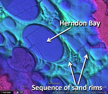
This LiDAR image shows Herndon Bay and the suggested sequence of sand rims. The authors write that "Basin migration was punctuated by periods of stability and construction of a regressive sequence of sand rims with basal muddy sands incorporated into the oldest rims." However, isn't it strange that through all the proposed migration the bay kept a perfect elliptical geometry?
Looking at a larger portion of the terrain around Herndon Bay reveals that some bays do not have multiple sand rims. If multiple rims are evidence of migration, this raises the question of why some bays do not migrate. And also, whether a bay that migrates can crash against a bay that does not migrate. This image also shows a bay 4.2 kilometers to the west of Herndon Bay that seems to have been stretched by movement of soil toward a drainage channel. Is this bay in the process of migrating and waiting to build up a rim toward the southeast end to restore its elliptical shape? All these are pertinent questions that are not answered by the terrestrial hypothesis. Let us look at another explanation.
Herndon bay has a major axis of 1070 meters and a minor axis of 670 meters, giving it a width-to-length ratio of 0.626. This ratio is within the range of 0.58 ± 0.05 reported in Zamora in 2017 and corresponds to an ellipse of a cone inclined at approximately 38.8 degrees. The shape of Herndon Bay is elliptical with no evidence of geometrical deformation. The lack of deformation from the prototypical elliptical shape may be considered evidence that the bay has not moved since its emplacement. This image shows a set of overlapping elliptical bays that follow the geological law of superposition. Herndon Bay is a bay that was emplaced later in time. According to the law of superposition, the red ellipse was created first, followed by the orange ellipse, and finally by the yellow ellipse, which corresponds to Herndon Bay. By recognizing that the Carolina Bays are elliptical conic sections, it becomes mathematically possible to determine the shape of the partially obscured bays from five points along their curves.
This is the original LiDAR image of Herndon Bay. This terrain was fairly flat before the saturation bombardment by the glacier ice boulders. The high-energy impacts liquefied the unconsolidated ground.
Splat! The first oblique impact created an inclined conical cavity corresponding to the red ellipse.
Splat! The second oblique impact created an inclined conical cavity corresponding to the orange ellipse.
Splat! The third oblique impact created an inclined conical cavity corresponding to the yellow ellipse, which is Herndon Bay.
The ground trembled from the high energy impacts. The inclined conical impact cavities in the liquefied soil transformed into shallow elliptical bays by viscous relaxation.
In 1977, Raymond Kaczorowski wrote a thesis describing an experiment on a sand table using a fan to simulate the winds that he proposed shaped the Carolina Bays and their rims. The wind direction in the graphic denotes an alternating wind direction, reversing 180º at regular intervals during the experiment. The wind modified the shape of the original pool, but it did not produce an elliptical shape.
The elliptical geometry of the Carolina Bays is a clue about their origin. Before LiDAR, the prototypical Carolina Bays might have been called oval, but now their elliptical geomorphology can be easily verified, and any hypothesis about their formation has to take into consideration that the bays are elliptical.
The terrestrial hypothesis states that the multiple dates of the terrain on which the Carolina Bays are found cannot support a single formation event. However, the hypothesis lacks a physical model that can produce elliptical features by eolian and lacustrine mechanisms.
The impact hypothesis states that impacts on liquefied soil are plastic deformations and that the stratigraphy is reconstituted by viscous relaxation. Therefore the various dates reflect the date of the terrain and not the date of bay formation. The impact hypothesis provides a physical model that creates conical cavities that transform into elliptical bays. The model also explains the formation of overlapping bays. Just like the adoption of the heliocentric model caused a great paradigm shift, the recognition that secondary impacts of glacier ice created the Carolina Bays will have repercussions in geology, history and astronomy.
