This presentation compares the Carolina Bays with modern oriented lakes as proposed by Raymond Kaczorowski in his 1977 thesis. The Carolina Bays do not have the same geomorphology as oriented lakes, and Kaczorowski's thesis does not provide a reliable foundation for the hypothesis that the Carolina Bays were created by eolian and lacustrine mechanisms.
Transcript:
This presentation discusses the Carolina Bays and Oriented Lakes. In 1977, Raymond Kaczorowski presented a thesis entitled "The Carolina Bays: A comparison with modern oriented lakes". He wrote that, quote "few investigations have been designed to compare or contrast the Carolina Bays with modern analogs in Alaska, Chile and Texas" end quote. Kaczorowski concluded that the Carolina Bays were ordinary terrestrial features that could have been formed by the action of wind and water over a long period of time. This presentation will compare the Carolina Bays with the analogs in Alaska, Chile and Texas proposed by Kaczorowski using LiDAR and satellite images.
The publication by Zamora in 2017 showed that most Carolina Bays have prototypical elliptical shapes and that a mathematical ellipse with the same width-to-length ratio as a Carolina Bay will fit the bay exactly after rotating and resizing the ellipse. This image shows the use of the Ruler Tool in Google Earth to obtain the width and the length of a Carolina Bay. This particular bay has a width of 670 meters and a length of 1070 meters. It is not necessary to use Google Earth to measure the bays in meters. Since only a ratio is needed, a ruler can be used to measure an image displayed on a computer or a printed image to get the width-to-length ratio.
There are many ways of getting an ellipse with the correct width-to-length ratio. I generally use the mathopenref website because it is easy to create an ellipse of different dimensions interactively. The image can be captured with a snipping tool for use with a graphics editor. I usually use GIMP, which is a free image editor that runs on Windows, OS X, and Linux platforms. I open the LiDAR image and the image of the ellipse with GIMP. I create a transparent layer on the ellipse and delete the white background. I then move, rotate and resize the ellipse to place it over the Carolina Bay that I measured. The opacity of the ellipse can be reduced to allow some of the LiDAR features to show through the ellipse.
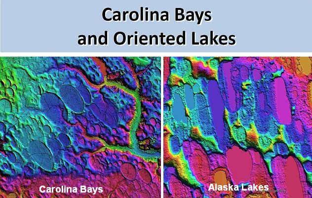
The final result is a LiDAR image with an overlapping ellipse that can be evaluated for congruency. The evaluation is easier if the ellipse is only 50 percent opaque and it is slightly smaller than the Carolina Bay so that the rim of the bay can be seen clearly along the perimeter of the ellipse. In these images we try to apply these same graphic techniques to the oriented lakes in Alaska mentioned by Kaczorowski. An ellipse with the same width and length as a lake does not fit the shape of the image of the lake well. We can pick any lake at random to repeat the ellipse-fitting procedure, but visual inspection indicates that the outline of the lakes is not likely to be congruent with any ellipses. This image shows a more detailed view of the fitted ellipses. The Carolina Bay conforms to the geometrical shape of the ellipse perfectly.
The margins of the Alaskan lake are irregular and protrude toward the interior of the ellipse or go outside the perimeter of the ellipse. A least-squares method could be used to calculate the goodness of fit, but it is obvious that the Alaskan lakes are not elliptical like the Carolina Bays. It is not surprising that the Alaskan lakes cannot be fitted with ellipses. This LiDAR image shows the different shapes and the rough borders of the Alaskan lakes. Although Kaczorowski wrote that the Carolina Bays were analogous to the Alaskan oriented lakes, it is evident that the Carolina Bays were not created by the same physical mechanisms as the lakes in Alaska.
Australia has oriented lakes east of Perth and in other regions. The lakes have a general oval structure and they occur in clusters. Looking at the Australian salt lakes from a higher point of view, we can see that the lakes occur as isolated water holes along fluvial channels that fill with water when the river overflows and then they become isolated during droughts.
Kaczorowski mentioned the oriented lakes in Texas. This is a satellite image southwest of Lamesa, Texas. The lakes are not elliptical, but they are neatly arranged in rows oriented in a northwest-southeast direction. Looking at the oriented lakes from a higher point of view that includes the city of Lamesa, Texas, we can see a stream that runs in the same direction as the oriented lakes. The Colorado River in Texas originates south of Lubbock, near Lamesa. The LiDAR image reveals that the orientation of the lakes is due to washboard-like geology of the terrain. The lakes are located along the trenches.
I looked for the oriented lakes in Chile mentioned by Kaczorowski and I was not able to find them. This is why it is a good idea to always include latitude and longitude for any geologic features. I hope this becomes a more common practice in the future. I found some oriented lakes at the tip of South America in Argentina not far from Tierra del Fuego. If there are any oriented lakes in Chile they are probably similar to these. The terrain has many thermokarst lakes like Alaska that are not elliptical, and the lakes are aligned along river c
LiDAR and satellite images make it clear that the Carolina Bays are different from oriented lakes in other regions of the world. The Carolina Bays have a mathematically elliptical shape with smooth edges. Overlapping bays maintain their elliptical geometry. The bays have raised rims around the ellipses. The major axes of the ellipses are oriented toward the Great Lakes. The Carolina Bays are located within 1,500 km of the Great Lakes, which was the range of the secondary impacts of glacier ice ejected by a meteorite impact on the Laurentide Ice Sheet. In spite of their regularity, some Carolina Bays may be deformed by terrain conditions and erosive processes.
The oriented lakes have different types of alignment. The alignment is usually toward lower terrain along fluvial channels. Lakes may also be oriented in the direction of prevailing winds. Oriented lakes usually do not have geometrically precise shapes, but some lakes may be elliptical by chance. If Kaczorowski had had access to LiDAR and satellite images, perhaps he would have reached a different conclusion. Kaczorowski's thesis was never published in a peer-reviewed journal, but it has been considered a seminal paper in support of the eolian/lacustrine hypothesis of the origin of the Carolina Bays. This cursory comparison makes it clear that the Carolina Bays do not have the same geomorphology as oriented lakes, and that the Carolina Bays should not be grouped in the same category as oriented lakes. In conclusion, Kaczorowski's thesis does not provide a solid or reliable foundation for the hypothesis that the Carolina Bays are similar to oriented lakes and that they were created by eolian and lacustrine mechanisms.
