 Index
Index

During the late Pleistocene Epoch, 12,900 years ago, a meteorite hit the Laurentide ice sheet in the Great Lakes area. The extraterrestrial impact ejected a barrage of glacier ice chunks in ballistic trajectories. The great energy of the ice impacts produced seismic vibrations that liquefied unconsolidated soil and made it possible for subsequent impacts to create inclined conical cavities that were modified by geologic processes into the shallow elliptical depressions known as the Carolina Bays. The width-to-length ratios of the Carolina Bays correspond to cones inclined at approximately 35 degrees, which is consistent with the ballistic trajectories.

On level terrain, the inclined conical cavities were modified by topographic relaxation into shallow depressions with the prototypical elliptical shape shown in Figure 1. However, on sloping terrain, the conical impact cavities were deformed when the liquefied terrain flowed downhill like a mud slide.

The elliptical bays occur mostly in the relatively flat areas of the Atlantic coastal plain, but the bays in inclined territory tend to be deformed. Figure 2 shows a location near the border of South Carolina and Georgia along the Savannah river that has deformed bays (Lat. 32.904774, Lon. -81.380051). The inclination of the terrain is shown by the elevation color gradient. The green center of the lower bays is at an elevation of 43 meters above sea level. The yellow represents an elevation of 48 meters, and the orchid pink represents 55 meters above sea level.
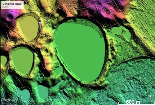
Figure 3 shows bays that have been distorted from an elliptical shape. The terrain where the distorted bays are found is at the boundary between the flat coastal plain and more elevated terrain with uneven ground that has preserved fewer Carolina Bays and has more dendritic stream erosion. The top part of the image shows the pink colors corresponding to a higher elevation.
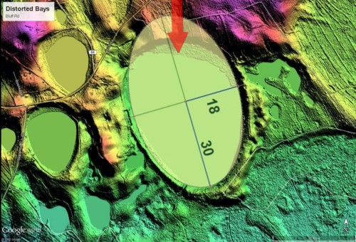
The distortion of the bays can be explained by soil movement from higher ground to lower ground, as illustrated in Figure 4. The image shows the distorted bay superimposed by an ellipse that is presumed to correspond to the shape of the original bay, and the red arrow shows the direction of possible flow of material. The same mechanism would apply to all the adjacent bays.

